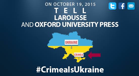
Activists of EuroMaidan France have apologized for spreading false information about the French publisher La Rocher: “We apologize for the error before de #EditionsRocher. However, the atlas of @LAROUSSE_FR is still sold today.”
Nous nous excusons auprès de #EditionsRocher pour cette erreur.
Par contre l'atlas de @LAROUSSE_FR est toujours en vente. #CrimeaIsUkraine— EuroMaidanFrance (@EuroMaidanFranc) October 24, 2015
Previously, they had published a tweet stating that La Rocher had published an Atlas where Ukraine was pictured without Crimea. As EuroMaidan France activists informed Euromaidan Press, they went to verify the information to the local bookshop. There they discovered that Rocher’s Atlas pictured the Crimean peninsula as part of Ukraine, and that the page of the Atlas that showed Crimea as not part of Ukraine was from the atlas of Larousse, which is still being sold in bookshops. We have updated our previous article to reflect this correction and apologize before our readers for the inconvenience.
The Atlas makes no distinction for Abkhazia and South Ossetia, breakaway unrecognized republics on the territory of Georgia, Transnistria, or the Golan Heights, which were occupied by Israel. Only Crimea, the annexation of which by Russia is recognized by only 12 countries, is pictured.
#Correction la carte publié hier venait de l'Atlas de @LAROUSSE_FR et pas Le Rocher#CrimeaIsUkraine pic.twitter.com/TVZdmkKeZM
— EuroMaidanFrance (@EuroMaidanFranc) October 24, 2015
In February 2014, unmarked Russian soldiers occupied Ukrainian territory and initiated the takeover of government buildings in the Crimean peninsula. On 16 March 2014, a so-called “referendum” was held in Crimea, following which the territory was attached to Russia. On 24 March 2014, 100 countries, including France, adopted the UN Resolution 68/262 that affirms the territorial integrity of Ukraine.


