Copyright © 2024 Euromaidanpress.com

The work of Euromaidan Press is supported by the International Renaissance Foundation

When referencing our materials, please include an active hyperlink to the Euromaidan Press material and a maximum 500-character extract of the story. To reprint anything longer, written permission must be acquired from [email protected].

Privacy and Cookie Policies.

Satellite imagery reveals ongoing fires at Russian-occupied offshore gas platforms in Black Sea

Some fires at the captured Ukrainian rigs continue for over two years.
satellite imagery reveals ongoing fires russian-occupied offshore gas platforms black sea drilling odesa shelf field photos sentinel-2 investigatororgua rigs 60de6fd3a12961ec
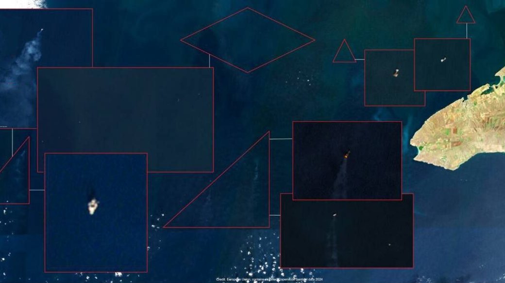
Offshore gas drilling platforms at the Odesa shelf field in the Black Sea. Photos: Sentinel-2, via investigator.org.ua
Satellite imagery reveals ongoing fires at Russian-occupied offshore gas platforms in Black Sea

Satellite imagery analysis has uncovered persistent gas flaring and new outbreaks of fire on Ukrainian offshore drilling platforms in the northwestern Black Sea that have been occupied by Russia and are being used as military facilities, the Center for Investigative Journalism reported.

Data from the Sentinel-2 satellite reveals continuous burning on Ukrainian drilling rigs and manifold block conductors in the Russian-occupied area since 2014. Fires have persisted for over two years, with new “hot spots” emerging, and smoke plumes currently visible on four of the 14 platforms, according to the Center.

Flaming drilling platform in the Black Sea, about 60 km off the western coast of Crimea (coordinates: 45.25791, 31.67358). Photo: apps.sentinel-hub.com, via investigator.org.ua

The latest satellite data also recorded smoke over a marine stationary platform on 12 August 2024, coinciding with a period when Ukrainian forces struck targets used by Russia for radio electronic reconnaissance and disrupting civilian vessel navigation, the Center said. Defense Express portal reported in August that the likely target of the latest Ukrainian attack was the MSP-17 platform, noting that at the time, NASA FIRMS’ wildfire monitoring satellites showed detected two fires in the northwestern Black Sea.

NASA data currently corroborates satellite imagery, revealing four thermal anomalies in the area between Odesa Oblast and occupied Crimea:

NASA FIRMS map, showing fires at gas rigs in the Black Sea. 7 November 2024.

After the Ukrainian strikes, the Chornomornaftogaz company, which is controlled by the occupation authorities in Crimea, announced the suspension of field operations, resulting in a 28.1% reduction in mineral extraction in the occupied peninsula, the center noted.

Related:

You could close this page. Or you could join our community and help us produce more materials like this.  We keep our reporting open and accessible to everyone because we believe in the power of free information. This is why our small, cost-effective team depends on the support of readers like you to bring deliver timely news, quality analysis, and on-the-ground reports about Russia's war against Ukraine and Ukraine's struggle to build a democratic society. A little bit goes a long way: for as little as the cost of one cup of coffee a month, you can help build bridges between Ukraine and the rest of the world, plus become a co-creator and vote for topics we should cover next. Become a patron or see other ways to support. Become a Patron!

To suggest a correction or clarification, write to us here

You can also highlight the text and press Ctrl + Enter

Please leave your suggestions or corrections here


    Euromaidan Press

    We are an independent media outlet that relies solely on advertising revenue to sustain itself. We do not endorse or promote any products or services for financial gain. Therefore, we kindly ask for your support by disabling your ad blocker. Your assistance helps us continue providing quality content. Thank you!

    Related Posts