

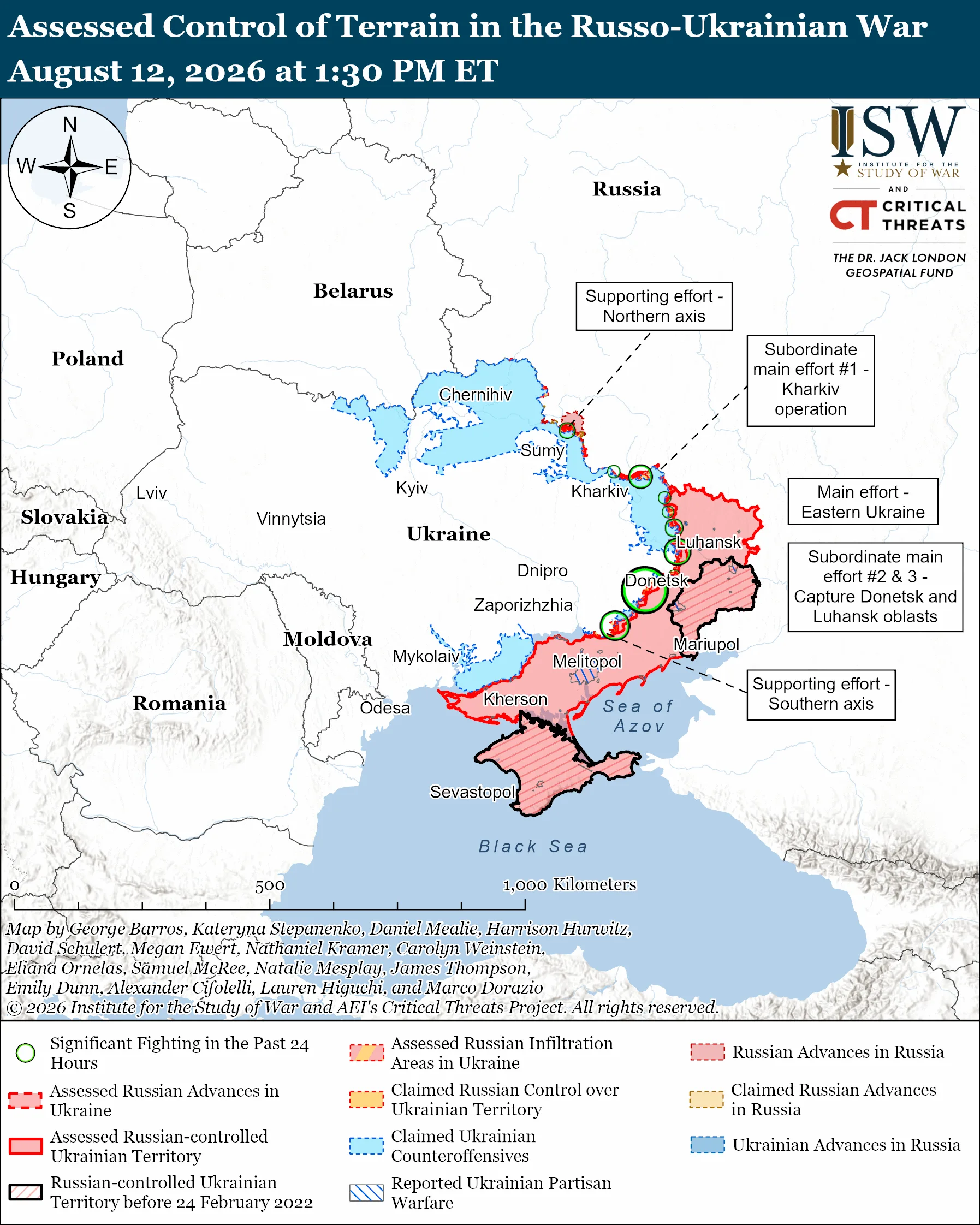
President of Ukraine Volodymyr Zelenskyy announced the results on 12 August after a briefing from Commander-in-Chief Mykhailo Drapatyi, Chief of the General Staff Ihor Skybiuk, and Airborne Assault Forces Commander Oleh Apostol.
Kyiv says the operation recaptured 745 km² and 26 villages across Dnipropetrovsk, Donetsk, and Zaporizhzhia oblasts. The Airborne Assault Forces and attached units carried it out. The goal was to stop Russian forces from advancing further and push them beyond the administrative border of Dnipropetrovsk Oblast. The President's Office put Russian losses at at least 9,550 killed and over 6,600 wounded. Ukrainian forces are continuing to build on the gains. The operation also added to Ukraine's prisoner exchange pool.
Since its 2023 counteroffensive stalled, Ukraine has mostly defended while Russia grinds forward, making any sustained Ukrainian advance rare. With Western aid uncertain and its own troops stretched, Ukraine rarely gets to trade defense for offense on its own land.
A reversal Russia paid for across the front
Ukraine has spent most of the past year on the defensive. The Oleksandrivka counteroffensive broke that pattern. For over six months, Ukrainian forces pushed forward rather than holding ground, and they did it in Ukraine's own Dnipropetrovsk Oblast, not on Russian territory.
The operation also hurt Russia elsewhere. Every unit Moscow sent to defend in the Oleksandrivka direction was a unit it could not use to attack other parts of the front, the US-based think tank ISW assessed. Russian recruitment is declining, which makes that tradeoff harder to absorb.
The numbers across the whole frontline tell the same story. Between late January and 12 August, Russian forces seized roughly 383 km² but lost about 234 km², according to ISW. The net Russian gain was far smaller than in previous seasons.
How Ukraine clawed the ground back
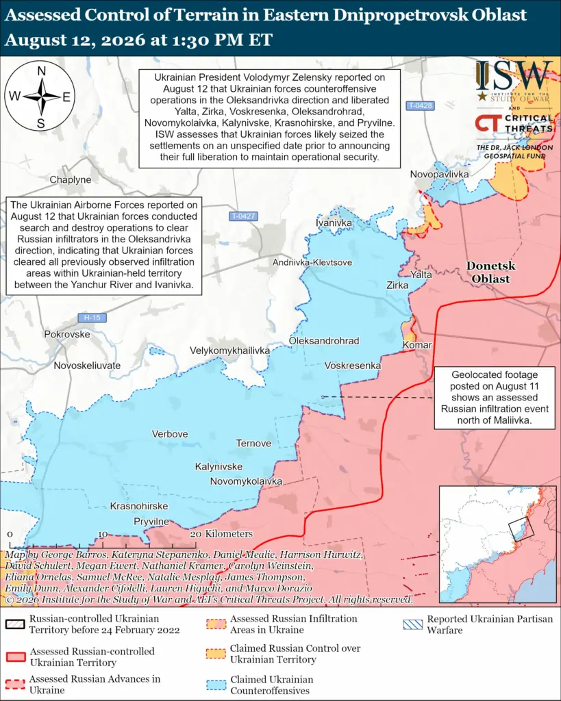
The counteroffensive began on 29 January, according to ISW. Texty reported it ran in two stages: January to May and May to August. It was one of two mutually reinforcing Ukrainian drives in the Oleksandrivka and Huliaipole directions. Both aimed to push Russia from Dnipropetrovsk Oblast and disrupt preparations for Russia's 2026 offensive.
Kyiv says the following 26 villages were liberated: Tolstoi, Novokhatske, Hrushivske, Zirka, Zelenyi Hai, Piddubne, Myrne, Tsehelne, Pryvillia, Zlahoda, Krasnohirske, Pryvilne, Novohryhorivka, Stepove, Kalynivske, Berezove, Novomykolaivka, Voskresenka, Oleksandrohrad, Yalta, Rybne, Maliivka, Sichneve, Ternove, Novoheorhiivka, and Zaporizke. The settlements span all three oblasts.
Where Kyiv's map and ISW's diverge
ISW described the results as evidence that Ukrainian forces can still carry out significant tactical advances and bring back limited mechanized maneuver on parts of the frontline.
It assessed that the success was likely the result of several factors working together: better Ukrainian operational planning, a campaign to suppress and destroy Russian air defenses, deeper strikes against Russian supply lines, Ukraine's advantage in tactical drones, and the 01 February Starlink cutoff that hit Russian forces in Ukraine.
Geolocated footage from 11 August showed Ukrainian forces holding positions southeast of Ternuvate and Vozdvyzhivka. Russian sources had claimed advances in those areas. ISW assessed those claims were likely largely exaggerated.
ISW's own mapping recorded roughly 627 km² of Ukrainian gains across the Oleksandrivka and northern Huliaipole directions combined. Even that two-direction total falls below Kyiv's 745 km² for the Oleksandrivka direction alone. ISW noted its conservative methodology likely underestimates Ukrainian advances.
The Airborne Assault Forces Command added that some flag-raisings over liberated villages were done at a "safe distance" from actual positions for operational security. This suggests forces had moved beyond the settlements they publicly named.
Read also
-
Russian drone cuts down unique energy line tower over Dnipro River in Kyiv. It can’t be rebuilt, and world is queuing for more power equipment
-
Hungary held $82 million in cash and gold from Ukraine for months. Now, it faces torture complaints in Europe’s top court
-
“Operation to strike Russian targets deep in swamps continues”: Ukrainian Commander Madiar says his unit hits 7,306 Russian troops in first half of October, up 59% on August


