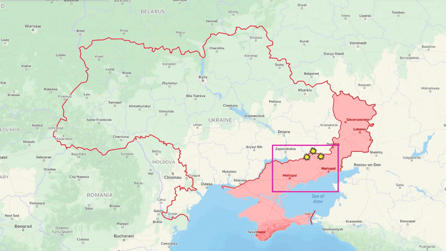
Ukrainian offensives yield progress in the Velyka Novosilka direction, southwestern Donetsk Oblast, while Kherson Oblast faces the altered landscape due to Russian-caused flooding.
Day 472: Jun 10
Today, there is a lot of news from the Velyka Novosilka direction.
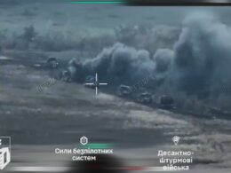
Here, after a short regrouping, Ukrainians ramped up the intensity of their attacks in order to leverage newly captured positions and generate new gains. One of the main axes of advance became the hills west of the river. If we look at the topographic map, we can see that Ukrainians gained a foothold right above the settlements, and as I told you last time, even if Russian claims were true and they indeed recaptured the settlements, they would not stay there for long due to the overwhelming fire from the hills. And this is exactly what happened.
Today Russian sources confirmed that they decided to retreat from Neskuchne to more reliable positions. Ukrainian sources also posted drone footage that confirms that Russians abandoned their positions around Storozheve as well. Some non-mainstream Russian sources claimed that the front line collapsed under the pressure of the second wave of Ukrainian attacks all the way to Makarivka.
But this is just the beginning because Ukrainians also launched a massive attack from Zolota Nyva. Russian sources reported that, at first, Ukrainians launched a small attack on Novodonetske to fix Russians forces and protect the flanks while almost immediately launching a powerful attack towards Urozhaine. Even the most prominent Russian sources confirm that Ukrainians very quickly cleared the tree lines, and the fighting is taking place right in front of the settlement.
As you can quickly notice, this attack completely cut off Russian forces in Blahodatne. Russian sources confirmed that Russian forces retreated to avoid being taken into a pocket, meaning that Ukrainians secured Blahodatne without firing a single shot.
There are also at least three more lines of attack along the western section of the front line, namely toward Rivnopil, Novodarivka, and Levadne. The freshest reports indicate that Ukrainians secured new tree lines in front of the settlements, however, the assault units are reportedly small, so for now, these are just supporting attacks. In total, in one week of assault operations around Veluka Novosilka, Ukrainians managed to liberate around 95 sq km of the ground.
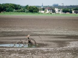
When it comes to the Kherson region, in the aftermath of the destruction of the Kakhovska Hydroelectric Power Plant dam, 600 sq km of the ground appeared underwater. This means that the topography of the region has completely changed. 90% of Oleshly and Hola Prystan, which are the main Russian strongholds where they were hiding most of their equipment, were submerged under the water.
The flooding has also destroyed many Russian first-line field fortifications that the Russian military intended to use to defend against Ukrainian attacks. Rapid flooding has forced Russian personnel to evacuate as fast as possible. Recently released footage shows how Russians are using boats from the local tourist center. Unfortunately for Russians, there were only blue and yellow boats left.
Recent footage also shows that Russians had to use their transport helicopters to evacuate from the Kinburn Spit because the flooding had reportedly cut off the main supply roads. Ukrainian Southern Operational Command Spokesperson Nataliya Humenyuk stated that Russian forces had to roll back by up to 15 km in some places.
Local residents also showed what happened above the dam. As the reservoir gradually empties, the river width has shrunk by multiple kilometers. In fact, if we look at the satellite footage, we can see that vast areas have turned into land. If we increase the image's contrast, we can also see how narrow the main river path is. This means that if the water levels continue to recede, Ukrainians will be able to establish a pontoon bridge and conduct a mechanized assault on a completely naked and unfortified part of the front line.
In our daily frontline report, we pair up with the military blogger Reporting from Ukraine to keep you informed about what’s happening on the battlefield in the Russo-Ukrainian war.
Read also:
- “Counteroffensive and defensive actions are taking place,” Zelenskyy says
- Ukrainians advanced up to 1,4 km near Bakhmut on 9 June – Ukrainian military
- Ukraine advances in east, south, Russian airforce “unusually active” – UK intel
- Frontline report: Ukrainian forces adjust strategy, push forward in Zaporizhzhia’s Orikhiv direction