
It was the summer 2014 and the war with Russia was in full swing. Ukraine was putting together its army which had been degraded during the years since independence, and new volunteer battalions were stepping into the fight against the aggressor. While Ukraine was all too aware who she was fighting against, it was not always easy to prove to the world that Russian tanks were on Ukrainian soil. Much proof of Russia’s invasion has since come to light, and more continues to do so.
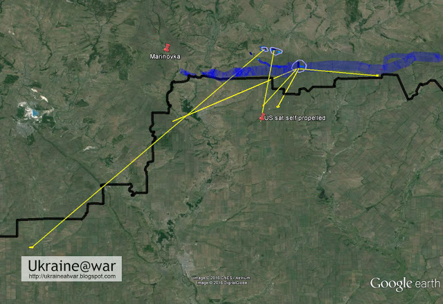
An investigation published by the Putin@war blog has revealed a major Russian invasion to the east of Marynivka, a village in the Donetsk Oblast close to the Russian border.

A strategic town on the way to Donetsk
The incident occurred here between 1 and 15 August 2014. However, the area around Marynivka was a blind spot on Google Maps at the time as the latest satellite map dated from August 2013. Investigations only became possible after a new map appeared on 22 February 2015. Despite the lengthy gap between the incident and the new map, evidence of the Russian invasion is still visible.
Before war started in early 2014, the length of the Ukrainian-Russian border was 2,295 km (1426 miles), of which 1,974 km were on land and 321 km at sea. In 2014, Ukraine tried to close the porous border with Russia by positioning major army camps along it, with Marynivka being a communication node for many other units. Therefore, Russia tried to cut Marynivka off in an attempt to isolate other units.

“This object is strategically important; by taking it the “militia” cut off a large group of Ukrainian troops. Also, this location is important for the control of the Ukrainian-Russian border,” pro-Russian media reported when Russian forces eventually took the area.
It is also worth mentioning that Marynivka opened the shortest way from Russia to the towns of Snizhne, Shakhtarsk and then on to the city of Donetsk.
Ukrainian camps shelled across the border from Russia
On the maps published by Putin@war, Ukrainian camps are identified.
Some tracks can only be observed on the 2015 maps, not on those from 2013. The maps indicate roads which are visible on both, multiple tracks which were the arteries running along the border leading to and supplying all the other Ukrainian camps; the main route from the upper camp to the East and the intensiveness of patrolling the area.
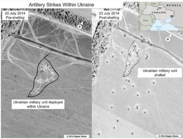
The maps reveal that the Ukrainian camps were intensively shelled by artillery. The craters can help to determine the direction of impact. One can then find an artillery position that may point in the same direction. The investigation found 4 directions from which Ukrainian camps were attacked.
One of the signs also shows that along with GRADs, Russia was using a longer range weapon. The traces are much bigger than a GRAD's and the distance to the target is much further – 55 km. The authors of the article suppose that it might be a sign of a Smerch attack.
This attack finds further confirmation in the maps of the artillery attack that the US released publicly, to show that they knew Russia was attacking Ukraine.
Russian camps and signs of Russian presence

The map also shows a Russian camp, where positions with buildings can be identified (red areas), along with camps where a lot of vehicles had been parked (green areas), fortified position with trenches (dark orange), tracks, most often indicating an artillery positions and GRAD positions (yellow).
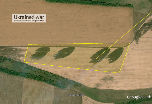
By the sides of the "official road" with a border post leading to Ukraine, a satellite picture shows dozens of tracks, meaning that at some time this area had been quite busy. The tracks lead into trees where, according to the article, in the lower four Russian camps around 200 vehicles were hidden.
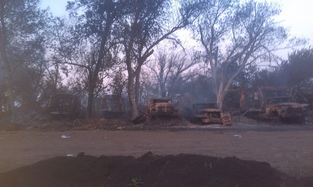
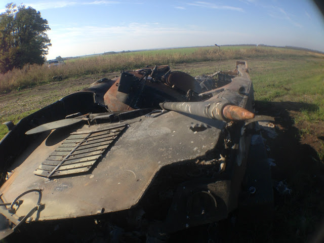
Further evidence of the incident there in August 2015 comes from wrecked military hardware. It is not so obvious from the satellite images that there was destroyed military equipment; however the evidence can be complemented by the lostarmour.info database (a Russian propaganda site) and by the geotagged photos from the Russian social network Vkontakte with Russian BMD-2 and BMP-2s.
One small area that has been shelled, comes from Ukrainian positions south of Marynivka. It means that the Ukrainian side had tried to launch a counterattack against the invasion. On the larger map we can see that it is on the route from the border crossings to the Ukrainian camps. It is also possible to determine the direction from which the tracks came. It was Russia's main hub into Ukraine, the huge Golovinka camp.

The desire of Russian soldiers to boast makes the early myth about absence of Russian troops in Ukraine even more absurd.
A man in the photo below, identified as Ruslan Khafizov (https://vk.com/id50251175) has a geotagged photo in his album with GRADs in Kryukovo, also he has another one further north, a photo from Golovinka and one more from near the invasion area. Ruslan's photos had been uploaded in September-October 2014, just after the Russian invasion. Later Kamaz-based GRADs (which are present on one of Khafizov’s photos) were seen inside Ukraine, in Donetsk and south of Torez.


Marynivka was a gateway for Russian military vehicles destroying military camps in Ukraine
Other parts of the Russian invasion of Ukraine has been further clarified. These were the Ilovaisk massacre and the Luhansk Airport attack.
The Ukrainian border camps were not only destroyed by artillery. With this invasion, the other border camps were cut off and hundreds of Russian vehicles flooded into Ukraine. This led to the fall and final destruction of these other border camps. This was the prelude to the two other major invasions.
The Golovinka base was the starting point of the operation. From there hundreds of vehicles drove north and set up camp 7 kms from the Ukrainian border. In the previous weeks the Ukrainian camps had already been shelled intensively.
On 12 August 2014 the Ukrainian army had established a break-through north of Dmytrivka and had been driving all the way up to Krasnyi Luch, leaving the Marynivka-Dibrivka area vulnerable.
That was the moment the Russians were waiting for to invade Ukraine, and cut off and take the Ukrainian positions.
This invasion was prepared and took place while Vladimir Putin was distracting the world with his “humanitarian white truck” charade.
Read also: Trojan convoys: Putin’s hidden invasion
An interesting detail is that during that time a convoy with more than a hundred vehicles was spotted on the road to Novoshakhtinsk.
The investigation cannot determine whether this convoy did indeed cross the border at the nearest Dolzhanskyi border crossing, but knowing about the Marynivka invasion that involved hundreds of vehicles, the convoy might have been heading there.
According to Google, it is exactly on the shortest route from the Rostov army camp to the Marynivka invasion camp.
Ukraine paid a high price for Marynivka with Ilovaisk tragedy
At the end of 2014, Tyzhden.ua published an article, with the author Yaroslav Tynchenko calling Marynivka a strategic mistake with fatal results. He pointed out that Ukrainian commanders’ inaction in the area of Saur-Mohyla led to the Ilovaisk tragedy later.
Saur-Mohyla is a strategic height in Donetsk Oblast near the road which starts in Marynivka. The area of Savur-Mohyla, where according to rumors the remains of 200 Ukrainian soldiers lay, was the first point of an expedition by the National Military History Museum of Ukraine People's Memory, which by agreement between the Ukrainian General Staff and the “other” side had to collect the dead bodies. The expedition started its work on 3 September 2014. Fortunately, rumors turned out to be false. However, the researchers found the dead, which, according to the official Ukrainian version, were not there. The investigation shows signs that Ukrainian soldiers were fighting for dear life against a wall of fire.
They hid in casual shelters. A major part of their equipment was destroyed, and mass desertion of mobilized soldiers started. On the night of 12 to 13 of August, it was reported that about 50 tanks were coming to attack Marynivka and Stepanivka from the Russian side. Someone in army command issued the order to evacuate the border towards the West - just like in 1941.
In total, on the road near Marynivka - Stepanivka - Petrivske, 17 dead soldiers and fragments of several fighters probably taken away by fellow soldiers were found. So the question which the author of the article in Tyzhden.ua has raised is: why were all these people were not evacuated sooner. The evacuation of the Saur-Mohyla area was only officially admitted on 2 September.
The journalist continues that in the second half of June 5,000 Ukrainian soldiers were blocked by Russian forces near the border and bombarded by rocket fire. In early August 2014, surrounded in a few “pots,” Ukrainian troops managed to get to other Ukrainian camps or were forced to lay down their arms.
On 27 July, battalions launched attacks near Saur-Mohyla and quickly broke the resistance of Russian Cossack troops and "militia" from the so-called “Donetsk Peoples Republic” ("DNR"). The next day they took Stepanivka which had been fiercely defended by “DNR” forces. After that, the path to the previously blocked units of the 72nd brigade was opened.
Battalions of the 30th and 95th brigades were advancing to the east and north, soon reaching the small but extremely important strategic town of Miusynsk. This happened on August 10. Only a few kilometers were left from Miusynsk to Debaltseve [The city which is situated on the eastern edge of Donetsk Oblast, and borders Luhansk Oblast]. This would present the Ukrainian side with the chance to separate the self-proclaimed "Donetsk People's Republic” from the “Luhansk People's Republic,” and in addition, completely encircle Donetsk and the surrounding cities.
The middle of August 2014 was the most dangerous for the existence of the "Novorossia" project. Judging by media reports in the Ukrainian media, it seemed that Ukrainian governmental circles were in a state of victorious euphoria. In this regard, along with the operation in Miusynsk another one was started at Ilovaisk. However, it was carried out very slowly, which made it possible for the enemy to collect all their reserves and throw them in the area of Saur-Mohyla, to the checkpoint Marynivka in particular. As a result of shelling from the territory of Russia, a significant part of the equipment of the units of the 30th mechanized brigade, which consisted of mobilized soldiers covering the rear of Miusynsk group, was destroyed. On August 13, the enemy attacked the checkpoint Marynivka from both sides of the Russian-Ukrainian border. After quickly breaking resistance of the demoralized Ukrainian units, Russian troops and so-called separatists took Marynivka and Stepanivka.
Meanwhile, the National Security and Defense Council was presenting maps to the public with lines of defense of Ukrainian troops in the area of Marynivka and Stepanivka. However, it is interesting to note that on the opposite side, Russian experts were also publishing detailed "plans of action" in the Internet that were dramatically different to the NSDC’s victorious ones. The pro-Russian side marked Marynivka and Stepanivka as being within "DNR"-controlled territory.
In the area of Miusynsk and the village of Bokovo-Platove, the 1st Battalion of the 30th Brigade and units of paratroopers from the 95th brigade were completely encircled. Meanwhile, one Russian column after another carrying military aid and volunteer soldiers were coming from Marynivka and heading towards Ilovaisk and Donetsk. In August 15, units of the self-proclaimed "DNR" continued their expansion, and soon reached the Uspenka checkpoint, creating ideal conditions for the mass invasion of Ukraine by regular Russian troops. The area of Saur-Mohyla did not pose any interference to Russian troop movements, resulting in it only being attacked and shelled on August 19.
There were a lot of comments in the Ukrainian media about an investigation into the Ilovaisk tragedy. However, the situation in sector D during 14-23 August is barely covered in the the published Interim Report. In the opinion of the article’s author, it would seem that the events in the Report have been deliberately ignored.
He concludes that the case of Ilovaisk has been investigated from the wrong side and places the guilt for the tragedy on people who “gifted” part of the state border in the area of the Marynivka checkpoint to the "DNR" diversionists and militias, letting Russian troops operate with impunity.


