


On 14 November, one of the managing organs of Open Street Map (OSM), the Data Working Group (DWG), changed its rules from 2014 and decided to modify the tags for Crimea in the OSB geodatabase: Ukraine’s administrative borders were cut off, and Crimea marked as territory belonging to Russia.
The DWG explained its decision by stating that the “OSM only seeks to represent the on-the-ground situation”:
“Crimea shall be part of the Russia administrative relation and not the Ukraine one as long as Russia has on-the-ground control in Crimea. The boundaries of Crimea shall be indicated as disputed, with the exception of water-based ones on the Black Sea or Sea of Azov where there is no dispute.
The Data Working Group takes no stance on if Russia’s control is legal or not, as that is not within our scope.”
Previously, Crimea belonged to both the Ukrainian and Russian administrative relations and was marked as disputed.
In the situation of Crimea, these conditions are mutually contradictory: Crimea is widely internationally recognized as Ukrainian, although it is controlled by Russia.
The Ukrainian team of OSM has expressed its disagreement with the decision and is calling upon the Ukrainian MFA, Embassy to the UK, Crimean Tatar Mejlis, and other officials to protest it:
“We state our disagreement with this decision, as it encroaches on the sovereignty of Ukraine as an independent state, the boundaries of which are recognized by the international community, EU countries, the UK, USA, UN, NATO, and other international organizations, and contradicts the principles of marking disputed territories (administrative units) and doesn’t correspond to the constant practice of tagging such territories (North Cyprus, Transnistria, Abkhazia etc). [It] jeopardizes the possibility of using the OSM data by the international community, in view of the sanctions already imposed on individuals and organizations guilty of the annexation of Ukrainian territories.”
OSM is an open source volunteer project which creates geospatial instruments for all to use for free. Since the project was founded in the UK in 2004, a huge number of maps has been created in the world using information in the geodatabase. OSM data is used by Wikipedia, Facebook, Apple, Microsoft, the UN, the World Bank, various state institutions, NGOs worldwide. OSM is important for the International Red Cross Committee and Red Crescent, as they allow operatively mapping areas of natural disasters. According to SimilarWeb data, only the site openstreetmap.org has 10mn views each month; however, the project’s data is used by thousands of independent online services and resources on the Internet.
This means that a huge amount of maps would now be made with Crimea marked as Russian, visually approving of the illegal 2014 landgrab.
The debate
A thread titled “OSMF silently sides with Russia?” has been opened on the OSM user forum. The author, Tomas Straupis, asserts that there are three practical outcomes to this decision:
PRACTICAL1: this will make it impossible to create a correct
political map using OSM data.

  PRACTICAL2: It is also EXTREMELY damaging to OpenStreetMap
reputation. Now all opponents of OSM will be able to point fingers at
this decision - "OSM recognises Crimeas annexation". And it now makes
us all participate in Russian (ruled) project.

  PRACTICAL3: While there are some talks about using OSM instead or
alongside of commercial GIS solutions in the context of EU INSPIRE
directive, such intentions will be seriously damaged by OSMF/DWG
actions, because Europe has a very clear position of not recognising
Crimeas annexation.
The main arguments in the ongoing discussion revolve around the OSM having the rule to reflect the on-the-ground situation. As OSM contributor wrote, “the default borders in OSM are those of de facto control and […] has nothing to do if we think that is legit, appropriate or anything similar, it is simply recording the fact.” Arguments in favor of including Crimea as Russian included this one: “looking at a map where Crimea is part of Ukraine may lead people to plan a trip to it, only to be stopped and possibly questioned” and “having Crimea as part of Ukraine on a map that shows what’s on the ground would lead people to think that the illegal invasion has been resolved and everything is back to normal.”
However, as Tomas answered, “going to Crimea without Ukrainian visa (and not via Ukraine controlled territory) would have legal consequences,” and “showing Crimea as part of Russia would also lead people to think that the illegal invasion is over, everything was “legalised” and issue settled, which is exactly the opposite of the reality.”
In his view, the existing rule to show Crimea as part of both Ukraine and Russia, with overlapping borders, is the best solution. In a written statement to Euromaidan Press, he wrote that this is not hard to implement technically and would fit the requirements of many more people.
In a subsequent thread titled “OSMF makes a political decision where should be a technical solution?”, Victor Shcherb raises some problems that OSM’s “on-the-ground” principle brings:
- Russia’s puppet “republics” in eastern Ukraine are not under the control of the Ukrainian authorities; does OSM change the border of Ukraine there too?
- Despite South Cyprus not controlling North Cyprus, OSM does not delineate North Cyprus. The discussion on this decision contains a statement about the UN’s non-recognition of North Cyprus. If that logic is taken into account, then Crimea should belong to Ukraine, as the overwhelming majority of UN countries do not recognize Russia’s annexation of the peninsula.
It appears that discussions between OSM contributors are ongoing.
Google maps solution
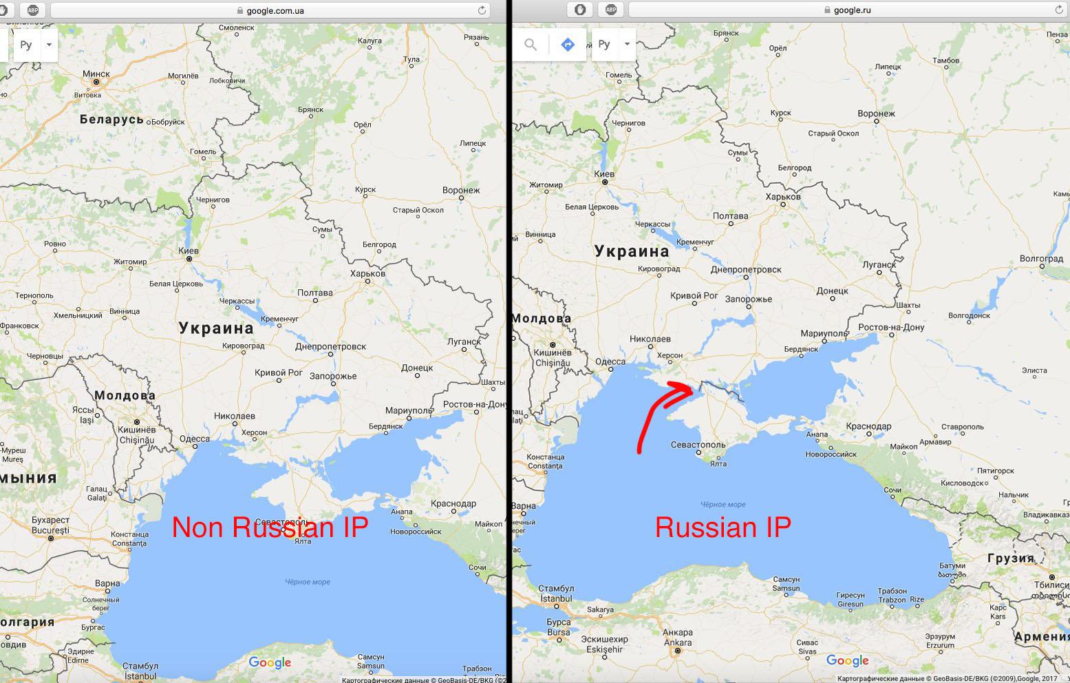
In 2014, Google Maps made a decision to use the regional definitions of international boundaries in its localized platforms. This has led to a situation where Google Maps depicts Crimea as Russian territory when viewed from a Russian IP, and as Ukrainian when viewed from an IP in the rest of the world. This policy also applies to North Ossetia and South Abkhazia, two breakaway regions of Georgia widely considered to be Russian puppet states.
Crimea in the upcoming UNGA resolution
If OSM’s “Crimea-as-Russia” rule is enforced, OSM’s maps would conflict an upcoming UN General Assembly resolution which is expected to be voted through in December 2018. Titled “Situation of human rights in the Autonomous Republic of Crimea and the city of Sevastopol, Ukraine,” the resolution, among other things, calls upon international organizations to refer to Crimea as occupied territory. Particularly, it requests international organizations and specialized UN bodies mark the Ukrainian peninsula in their official documents only as “The Autonomous Republic of Crimea and Sevastopol (Ukraine), which are temporarily occupied by the Russian Federation.”
If the resolution is voted through in December, international organizations would have difficulties in using OSM data for their maps, and the OSM would explicitly go against the decisions of the UN.